What is the Southern Flow Corridor – Landowner Preferred Alternative Project (SFC-LPA) acreage?
The total project area is 642 acres, 519 acres of which will be restored to full tidal inundation.
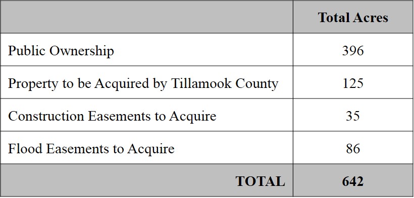
Who owns the project area?
As of June 2014, 396 acres are publicly owned, predominately by Tillamook County. The City of Tillamook owns a few small parcels on the perimeter of the project area. Tillamook County will acquire an additional 125 acres of private land, 35 acres of temporary construction easements, and 86 acres of permanent flood easements.
Is the SFC-LPA a flood project or a restoration project?
Both. The SFC-LPA was developed as a flood project, but it restores tidal wetland habitats and ecological function as a direct consequence of removing levees and reconnecting 14 miles of ancient channels to the river systems.
How much farm land is being taken out of production?
Of the 642-acre project area, 185 acres will no longer be farmed. Agricultural use will continue on 86 acres. The remaining acreage is currently water, wetlands, fill, or developed areas.
When will we see the project benefits?
Some benefits, such as flood reduction and fish access to off-channel rearing areas, will be immediate. Longer term benefits, such as increased adult salmon returns and marsh rebuilding, will vary from three to five years to decades.
How will the project reduce flooding?
The Southern Flow Corridor is a “natural overland floodway” that is currently blocked by numerous levees and dikes. The project will remove these blockages and set back remaining levees in order to provide an unobstructed flow corridor. The net result is that flood levels are reduced over a wide area in the lower Wilson floodplain and even to some degree the lower Trask and Tillamook River systems.
The positive economic and social effects that this project will have on flood damage reduction cannot be over-stated in a community that has been ravaged by flooding in recent years. According to Northwest Hydraulic Consultants (NHC), computer modeling predicts water level reductions of up to 1.5 feet will be achieved for all floods from small frequent events through a 100 year event. The area of flood level reduction is over 3,000 acres and encompasses the lower Wilson, Trask, and Tillamook River floodplains. There are 540 residential, commercial, and agricultural structures located in the area of benefit. Total estimated economic benefits accrued from avoided flood damages over a 50-year project life are $9.2 million.1
1Collins, V. October 24, 2012. Memorandum to Paul Levesque & Aaron Palter re: Modifications to Benefit-Cost Analysis and Additional Supporting Information, AND Northwest Hydraulic Consultants. March 2012. Final Southern Flow Corridor Benefit-Cost Analysis – Prepared for: Tillamook Oregon Solutions Design Team Under contract to Tillamook County.
Are there other socio-economic benefits?
Recreational Spending. The project site is within close driving distance to the state’s population centers and offers excellent public use opportunities. As predominately publicly owned land managed for fish, wildlife, and associated resource values, this site will provide expanded opportunities for kayaking, hunting, fishing, hiking, wildlife viewing, and interpretive activities. These activities are vital to regional and local economies. Spending on outdoor recreation, sport fishing, and hunting provides sustainable revenue for local businesses, government, and natural resources agencies. In Oregon in 2008, over $2.5 billion was expended on shellfishing, fishing, hunting, and wildlife viewing.2 In Tillamook County $63.5 million was generated in travel-related expenditures, much of which was recreation based. Wildlife viewing alone generated $18.6 million in travel-generated expenditures in 2008. The SFC-LPA is estimated to provide a sport fishing value of $4.67 million over 50 years.1
Jobs. Over the life of the project and for varying periods, an estimated 50 jobs will be supported. The majority of the jobs will perform construction, monitoring, and engineering design services. As contractors use local services such as restaurants, supplies, and other contractors, the local economy will also receive a boost.
2Runyan, Dean. 2009. Fishing, Hunting, Wildlife Viewing, and Shellfishing in Oregon, 2008. Prepared for the Oregon Department of Fish and Wildlife and Travel Oregon. Dean Runyan Associates, Portland, Oregon.
What are the fisheries benefits?
Loss of estuarine rearing habitat limits salmon production in the Tillamook Bay Basin.3 SFC-LPA implementation addresses the habitat-based factors limiting production:
- Habitat Access & Quantity: 14 miles of channels reconnected and restored
- Habitat Quality: Re-establishing natural channel structure and hydrologic function and improving water quality
The project location is considered to be ideal, largely because it lies within the migration pathway of salmon that emigrate as juveniles from the Wilson, Trask, and Tillamook rivers; and it is also within the potential home range of juveniles from other tributaries and rivers. The Oregon Department of Fish and Wildlife estimates that the 519 acres of restored wetland will annually produce 6,000-9,000 adult coho (average) and 9,000-14,000 with good ocean conditions.4
3Nicholas, J.W. and D.G. Hankin. 1988. Chinook salmon populations in Oregon coastal river basins: Description of life histories and assessment of recent trends in run strengths. Oregon Department of Fish and Wildlife. Information Report Series Fisheries Number 88-01. 4Nickelson, T. 2012 Futures Analysis for Wetlands Restoration in the Coquille River Basin: How many adult coho salmon might we expect to be produced? A Report to the Nature Conservancy.
How will we know if the project is successful?
Project monitoring is essential to evaluating whether the SFC-LPA has met the flood attenuation and ecological function goals. Only carefully targeted, science-based monitoring can provide the clear information needed to document project outcomes, provide accountability for the large public investment (over $10 million), and inform adaptive management, if needed.
Under the guidance of the Monitoring Advisory Committee, the Institute for Applied Ecology and Confederated Tribes of Siletz Indians have developed an extensive monitoring plan. Monitoring will occur before and a minimum of six years after construction and evaluate the following parameters: Vegetation, soils, groundwater level, juvenile salmon use, flood levels, tidal hydrology, macroinvertebrates, water quality, channel morphology, and sediment accretion.
How long will the project last?
From an engineering perspective, the estimated useful design life is 50 years. There will be maintenance of the project required, just as there is now for the existing tidegates and dikes. A reduced maintenance need is estimated because there are five fewer miles of levee to maintain and the new levees are almost all set back from the river channels. New drainage and flood structures will be constructed of non-corrosive, long-lived materials to ensure function over the design life.
From a habitat perspective, removing the levees and reconnecting channel restores the natural processes within the project area, which will sustain ecologic functions indefinitely.
What is the EIS?
FEMA is providing substantial funding to the SFC-LPA project through their Disaster Assistance Program. To ensure compliance with federal regulations, FEMA is preparing an environmental impact statement (EIS) to compare the benefits and impacts of the SFC project to other alternatives. Biological, water, physical, and cultural resources will all be assessed, along with construction impacts and socio-economics. Refer to FEMA’s NEPA desktop reference for general information or southernfloweis.org for the SFC-LPA EIS process.