 News
NewsWhat is the Aquatic Inventories Program
Blog Post By Leo DiNola
Our monitoring team has been busy the past few weeks collecting data using the Aquatic Inventories (AQI) program’s framework. The AQI program was developed by the Oregon Department of Fish and Wildlife (ODFW) in 1989. It is used to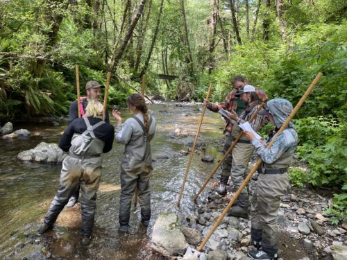 quantify stream habitat conditions, such as total shade, changes in water speed, and cover from predators for fish and amphibians. With fisheries under strain, monitoring of habitat and spawning grounds is a way to provide insight into the health of our coastal watersheds.
Our devoted monitoring team, Flynn Delany and Lisa Defillips, spend up to 10 hours in the field per day wading through the streams that make up the Oregon coast’s watershed. They collect data with this protocol to better understand what is successfully improving stream habitat and which areas need more attention. Having this data helps guide our future work, and shows the organizations that provide us with funding that their money is making a real difference.
Gear in the Field
 When performing an AQI survey, we look for features that are important for salmon habitat. To perform these surveys our team uses ArcGIS, a mapping software for navigation, and Survey 123, a program that ties the observations to GPS points for later reference. Our team wears waders, with detached felt soled shoes for grip in the water, and a raincoat or other weather-appropriate clothing. They are equipped with a two-meter long depth staff that also doubles as a walking stick, marked in meters and tenths, with a felt bottom for grip, as well as a clinometer, which measures the angle of slope, and a range finder, for long distance measurement. Our team also carries one phone, each preloaded with Survey 123 for measurement, and an iPad mini for navigation. We equip all field crews with a safety backpack with a satellite locator, a first aid kit, sunscreen, bug spray, and bear spray, and other incidentals.
One Reach at a Time

Each stream is separated into smaller sections called reaches. A reach is a portion of stream that is defined by some functional characteristic or identified in advance via survey design. We categorize the surrounding area based on land use, water temperature, vegetation type, and tree size class. We also take into account the size and slope of the valley, and measure the flood prone width and height.
Our monitoring team works upstream categorizing the habitat units: these are subunits within the reach, that are separated by changes in the water movement, depth, or slope. The stream is subdivided into channel geomorphic unit classes of unit types: pool, sub-unit pool, fast water, step, and special case units.
Pools are defined as being moderately deep with slow moving water; there are many other types of pools that are explained in depth in the AQI handbook on page 13. Salmon typically prefer a lateral scour pool which is defined in the handbook as a pool “formed by flow impinging against one stream bank or partial obstruction (logs, root wad, or bedrock).” Essentially these pools have a deeper channel running to one side of the pool, rather than running straight through the middle.
Glides look similar to pools, both having slow flow without surface turbulence. However there are a few distinguishing features that separate them. Glides generally have a uniform depth whereas pools have deeper and shallower parts. The main distinguishing feature of a glide is the homogeneity, meaning that the bottom is uniform.
Healthy Habitat for Salmon
Salmon prefer slow moving water, so glides and pools are heavily utilized by salmon across species. When streams have pools and glides, it allows for the salmon to spread out across the channel to feed without being swept away by the current. The deep water allows for a gradient of temperature, allowing the fish to move up or down depending on their preference. Salmonids prefer clear, slow moving streams as habitat for fry and to spawn. The optimal temperature range for the development from eggs to Alevin (small fish with an attached yolk for food) in Chinook salmon is from 46.4 degrees fahrenheit to 53.6 degrees fahrenheit.
Salmon use the streams to travel to the ocean or spawn depending on the stage of their life. AQI data collection helps us understand where the conditions are right for salmon to spawn, and how effective the steps we have taken, like placing log jams, have been.

It’s not all for the salmon though, sometimes our monitoring team is lucky enough to see other creatures, like amphibians and signs of elk, deer, beavers and bears.
All of these different creatures play their own critical role in keeping the forests healthy and the streams clean and clear. Habitat management is more than just looking at maps, with AQI we can gather data first hand about the current state of our ecosystems and make more informed choices about what is needed rather than guessing.
To learn more about AQI visit the Oregon State Forestry Website here, or view the booklet here
To support our work please consider donating here
References:
https://www.webapps.nwfsc.noaa.gov/assets/11/7389_10232012_174142_Bergendorf2002.pdf
https://odfw-aqi.forestry.oregonstate.edu/objectives-methods-history